Portal:Oceania
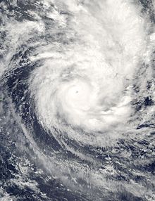
The Oceania PortalOceania (UK: /ˌoʊsiˈɑːniə, ˌoʊʃi-, -ˈeɪn-/ OH-s(h)ee-AH-nee-ə, -AY-, US: /ˌoʊʃiˈæniə, -ˈɑːn-/ ⓘ OH-shee-A(H)N-ee-ə) is a geographical region comprising Australasia, Melanesia, Micronesia, and Polynesia. Spanning the Eastern and Western Hemispheres, at the centre of the water hemisphere, Oceania is estimated to have a land area of about 9,000,000 square kilometres (3,500,000 sq mi) and a population of around 44.4 million as of 2022. When compared to the continents (which it is often compared to, not including Australia), Oceania is the smallest in land area and the second-least populated after Antarctica. Oceania has a diverse mix of economies from the highly developed and globally competitive financial markets of Australia, French Polynesia, Hawaii, New Caledonia, and New Zealand, which rank high in quality of life and Human Development Index, to the much less developed economies of Kiribati, Papua New Guinea, Tuvalu, Vanuatu, and Western New Guinea, while also including medium-sized economies of Pacific islands such as Fiji, Palau, and Tonga. The largest and most populous country in Oceania is Australia, and the largest city is Sydney. Puncak Jaya in Highland Papua, Indonesia, is the highest peak in Oceania at 4,884 m (16,024 ft). The arrival of European settlers in subsequent centuries resulted in a significant alteration in the social and political landscape of Oceania. The Pacific theatre saw major action during the First World War with the Japanese occupying many German territories. During the Second World War, Allied powers the United States, Philippines (a U.S. Commonwealth at the time) and Australia fought against Axis power Japan across various locations in Oceania. (Full article...) Selected geographic article -Hunter Island and Matthew Island are two small and uninhabited volcanic islands in the South Pacific, located 300 kilometres (190 mi) east of New Caledonia and south-east of Vanuatu archipelago. Hunter Island and Matthew Island, 70 km (43 mi) apart, are claimed by Vanuatu as part of Tafea Province, and considered by the people of Aneityum part of their custom ownership, and were claimed by France as part of New Caledonia. Small, arid, without fresh water and not easily accessible, the islands had no interest for Britain or France during their colonisation of the Pacific in the course of the 18th and 19th centuries. France officially annexed both islands in 1929. In 1965, the United Kingdom also claimed the two islands, as part of the New Hebrides. France conducted a symbolic occupation in 1975. In 1980, on its independence, Vanuatu claimed sovereignty, but made no occupation of the islands. In 1979, Météo-France set up an automatic weather station on one of the islands, and the French Navy regularly visits both of them. (Full article...)Related portalsSelected article -Severe Tropical Cyclone Percy was an extremely powerful tropical cyclone which was the third and last Category 5 cyclone to form in the 2004–05 South Pacific cyclone season. The seventh named storm and the fourth and final severe tropical cyclone to form during the 2004–05 South Pacific cyclone season. Percy originated as a tropical disturbance on February 23. Over the course of the next few days, the system organized while moving east-southeastward, before intensifying into a Category 1 tropical cyclone on the Australian region scale on February 26. The system quickly intensified, reaching Category 4 status later that day. On the next day, Percy was steered southward by a blocking ridge of high pressure, while stretched out the structure of the storm into an elliptical shape, weakening it back to Category 3 status. Afterward, the storm rapidly reintensified, reaching its peak intensity as a Category 5 tropical cyclone on March 2. Afterward, Percy encountered increasing wind shear and weakened once again, turning southeastward on the next day. On March 5, Percy transitioned into an extratropical storm, before dissipating soon afterward. Percy was also the most damaging of the South Pacific February cyclones that year, as it battered the Cook Islands, which were still recovering from the impacts of Cyclones Meena, Nancy and Olaf. Percy then devastated the island of Tokelau, leaving many homeless and millions in dollars in property damages (although exact damage figures are unavailable). Because of warnings in anticipation of the storm, there were no deaths and there were only a few injuries. (Full article...)Did you know -
General images -The following are images from various Oceania-related articles on Wikipedia.
TopicsSubcategoriesThings you can doAssociated WikimediaThe following Wikimedia Foundation sister projects provide more on this subject:
In other languagesWikipedia in other languages used in Oceania:
More portals |


