
File:Petsamo.png

Size of this preview: 507 × 599 pixels. Other resolutions: 203 × 240 pixels | 406 × 480 pixels.
Original file (800 × 945 pixels, file size: 30 KB, MIME type: image/png)
| This is a file from the Wikimedia Commons. Information from its description page there is shown below. Commons is a freely licensed media file repository. You can help. |
| Description |
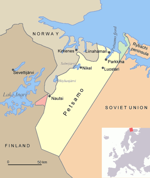
English: Map of Petsamo area in northern Finland/Soviet Union/Russia. The green area is the Finnish part of the Rybachi peninsula (Kalastajasaarento) which was ceded to the Soviet Union after the Winter War. The red area is the Jäniskoski-Niskakoski area ceded to the Soviet Union in 1947. |
| Source | Own work |
| Author | Jniemenmaa |
I, the copyright holder of this work, hereby publish it under the following licenses:

|
Permission is granted to copy, distribute and/or modify this document under the terms of the GNU Free Documentation License, Version 1.2 or any later version published by the Free Software Foundation; with no Invariant Sections, no Front-Cover Texts, and no Back-Cover Texts. A copy of the license is included in the section entitled GNU Free Documentation License. |
| This file is licensed under the Creative Commons Attribution-Share Alike 3.0 Unported license. | ||
| ||
| This licensing tag was added to this file as part of the GFDL licensing update. |
You may select the license of your choice.

|
This map image could be re-created using vector graphics as an SVG file. This has several advantages; see Commons:Media for cleanup for more information. If an SVG form of this image is available, please upload it and afterwards replace this template with
{{vector version available|new image name}}.
It is recommended to name the SVG file “Petsamo.svg”—then the template Vector version available (or Vva) does not need the new image name parameter. |
File history
Click on a date/time to view the file as it appeared at that time.
| Date/Time | Thumbnail | Dimensions | User | Comment | |
|---|---|---|---|---|---|
| current | 19:08, 17 June 2015 | | 800 × 945 (30 KB) | Hohum | Clearer |
| 17:48, 1 August 2005 |  | 800 × 945 (70 KB) | Jniemenmaa | Map of Petsamo area in northern Finland/Soviet Union/Russia. The green area is the Finnish part of the Rybachi peninsula which was ceded to the Soviet Union after the Winter War. The Red area is the Jäniskoksi area ceded to the SU some years after the C |
File usage
The following pages on the English Wikipedia use this file (pages on other projects are not listed):
Global file usage
The following other wikis use this file:
- Usage on ar.wikipedia.org
- Usage on ba.wikipedia.org
- Usage on ca.wikipedia.org
- Usage on cs.wikipedia.org
- Usage on da.wikipedia.org
- Usage on de.wikipedia.org
- Usage on eo.wikipedia.org
- Usage on es.wikipedia.org
- Usage on eu.wikipedia.org
- Usage on fi.wikipedia.org
- Usage on fr.wikipedia.org
- Usage on gl.wikipedia.org
- Usage on hu.wikipedia.org
- Usage on it.wikipedia.org
- Usage on nl.wikipedia.org
- Usage on nn.wikipedia.org
- Usage on no.wikipedia.org
- Usage on pl.wikipedia.org
- Usage on pt.wikipedia.org
View more global usage of this file.